The Hanging Lake trail was buried in mud, rock and charred timber following intense rain. But the oasis was untouched by debris flows and the Forest Service hopes to rebuild a more sustainable path.
White River National Forest ecologist Liz Roberts picks up her pace as she climbs the final, steep steps to Hanging Lake. She’s seen pictures of the pristine oasis clouded by mud and silt after devastating debris flows last week.
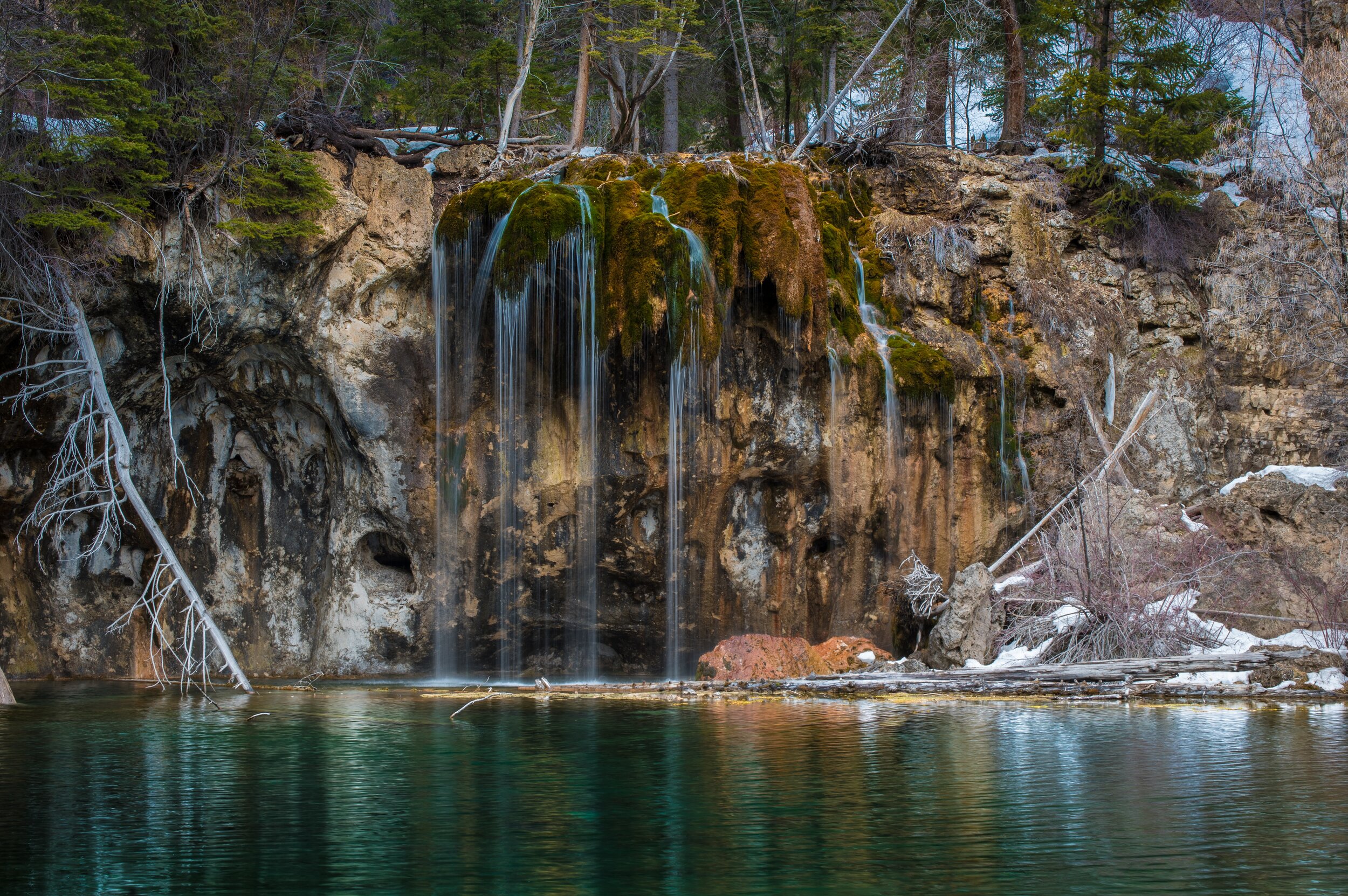
“Wow the lake has cleared up,” she says at the edge of the lush travertine pool swirling with deep green and blue hues.
Roberts, who has spent most of the last year reseeding vegetation in the scorched highlands of Glenwood Canyon following last year’s Grizzly Creek fire, marvels that the unique flora on the cliffs below the iconic Hanging Lake waterfall seems untouched by the canyon’s recent storms and fire.
“The vegetation recovery has been very impressive with this fire,” Roberts says.
Last week the White River National Forest closed the popular Hanging Lake Trail after torrential rains — including a once-in-500-years downpour — flushed countless tons of debris down Dead Horse Creek and over cliff walls, burying portions of the 1.2-mile trail in several feet of rocks, mud and charred timber.
The agency brought a gaggle of reporters up the trail Wednesday, revealing not just the damage of the debris flows, but the opportunities emerging from the devastation.
The oasis remains untouched
White River hydrologist Justin Anderson hiked directly past the lake and beelined further up to Spouting Rock, where water from the East Fork of Dead Horse Creek gushes through rock and into Hanging Lake.
It was clear as glass.
Another good sign.
Anderson had toured the burn zone in a helicopter and did not see much charred debris in the East Fork of Dead Horse, so he had a feeling Spouting Rock would not get clogged.
“This confirms what I suspected. Anywhere we’ve had debris flows come over waterfalls you can really see the damage … but right here I’m not seeing that,” he says amidst the mist of the Spouting Rock waterfall. “In other cliffs … we’ve seen a huge amount of water and debris and boulders and logs just free falling off a cliff. Not so here.”
There is hope that as debris flushes down the canyon walls, eventually the storms that batter Glenwood Canyon and close Interstate 70 will be less damaging. There is only so much loose rock and dirt that can wash down the cliffs above the interstate.
“The experts tell us we will continue to see debris flows but with each big flow we do move the sediment that has been stored and we get closer to more clear-water floods,” Anderson says.
Yet another upside of the living laboratory that Glenwood Canyon has become after the Grizzly Creek fire: Before and after aerial lidar images of the canyon are helping the U.S. Geological Survey scientists better model where and when debris flows might strike burn zones.
The U.S. Geological Survey models have been impressively on-point in Colorado this summer, with flows closely mirroring the survey’s maps showing canyons and gullies with increased likelihood of debris flow in burn zones. The research coming out of Glenwood Canyon is helping the survey’s scientists model even more accurately.
“And that sets us up in the future,” Anderson says, “for doing a better job of protecting the highway as well as safety, with better early-detection systems.”
Roberts spent the entire hike scanning for invasive weeds that were swept from the aspen groves atop Glenwood Canyon down into the Dead Horse Creek drainage, where there are very few noxious weeds.
“Here’s an example of something I worry about,” says Roberts as she reaches the edge of Hanging Lake and finds a small field of weeds, including common mullein and thistle. “We need to come in and treat this. We want to give our native plants the opportunity to flourish.”
The thousands of tiny yellow seeds in each mullein plant, she says, can last in soil for 100 years.
“Once they get established in a place it’s a constant effort to get ahead of them,” Roberts says. “But overall, the species diversity in the recovery has been amazing. We are headed in the right direction.”
Forest Service folks are a glass-half-full lot. Especially when they are talking with reporters. It’s rare to hear doom-and-gloom from a federal land manager.
So it’s not that surprising that Roger Poirier, the recreation staff officer for the White River National Forest, shares the enthusiasm of Roberts and Anderson, even though the recreational impacts in Glenwood Canyon have been extraordinary.
Rapids in the Colorado River have been forever changed by massive rockslides. Closures have pinched access to the river. The bike path along the river is buried in mountains of rock in some spots and completely submerged in other spots. And now Hanging Lake, a jewel in the Glenwood Canyon playground, is closed for the season and maybe longer.
Where Roberts likes the canyon’s plant recovery and Anderson is happy with how the debris flows have not impacted Hanging Lake, Poirier hopes to reimagine the trail that climbs up Dead Horse Creek.
Poirier sees a chance to rebuild a better, most sustainable trail that can last another 100 years.
Keep reading on the Colorado Sun.
Related Links
Vail Resorts announces opening dates — with no plans for last season's pandemic restrictions
America’s Hottest Zip Code Isn’t in New York or L.A. - It's in Colorado Springs
5 Strategies to Start Repaying Your Student Loans + Become Debt-Free
If there is a home that you would like more information about, if you are considering selling a property, or if you have questions about the housing market in your neighborhood, please reach out. We’re here to help.
